
Activity Type: Mountain Biking, Level of Difficulty: Non-Technical to Very Technical
Mountain Range or Region: Boise Front, State: ID, Country: USA
Vertical: maximum vertical approximately 4,500 ft. (Most of the rides in the GPS data are in the 1,000 – 3,000 foot vertical climbing range).
Miles of trails: 130+
[forecast location=”Boise, Idaho” caption=”Weather for Boise” measurement=’F’ todaylabel=”Today” datelabel=”date(‘m/d/Y’)” highlow=’%%high%%°/%%low%%°’ numdays=”5″ iconset=”Contemporary” class=”css_table_class” cache=”true” width=”100%”]
Hi-Adventure Mountain Biking Playlist:
Boise Foothills Rides: For individul maps and data on these rides, see: GPS-Exchange.com
Click here for a full size map
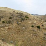
The Boise Foothills offer excellent mountain bike riding. The area covered in this GPS download stretches from urban parks into semi-arid hills and includes higher elevation trails that go to over 7,000 feet above sea level. The city of Boise is just less than 3,000 feet. The trails covered in this route are primarily a part of Boise’s Ridge to Rivers trail system. This system is a successful partnership between a vibrant and active mountain biking organization, other outdoor oriented groups, the city, private land owners and public lands. To learn more about this partnership, you can visit the Partnership page on the Ridge to Rivers trail system.
My Top Rides
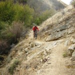
After work ride: Camelback/Fort Boise via Shane’s Loop. This ride features three sustained climbs and a short, grueling climb near the end. The primary downhill section is Trail 5, (steep sections and lots of jumps).
Kick your butt ride: Hardguy up-and-back. This isn’t one of the longest rides, but it is a very tough climb – approximately 2,200 feet of elevation gain in 6 miles of almost constant uphill riding. That’s the “bad news”. The “good news” is that there isn’t a lot of traffic on this trail and the downhill is exciting!
The big loop ride: Fort Boise Reserve Big Loop. This ride starts at FBR parking lot, goes up Shane’s, 3 Bears, and 5 mile gulch all the way to the ridge road at the top for a gain of over 3,000 vertical. It then crosses over to the 8th street extension via Trail 4. After a short ride on the dirt road, you hit Scott’s, Corrals, back on Trail 4 after crossing 8th street again and then Crestline to the Military Reserve Connection. That puts you on Mountain Cove and you can follow it back to the Reserve parking lot. This is a 21 mile ride.
Most technical: Dry Creek and Shingle Creek. Sustained sections of steeps, rock outcrops, lots of stream crossings and narrow trail sections. Recommended access points to these are either directly off from Bogus Basin Road for an “up-and-back”, or for a loop I do the Hardguy ride up and connect in from the Ridge Road.

Nice and easy: FB Reserve – Rich’s Loop. Named after my friend that I ride with quite a bit. This is a nice little ride that is great for beginners and novices. This is where Rich started me out as I was learning how to ride mountain bike trails.
Go to the Hi-Adventure Mountain Biking Video Playlist.
About the GPS data
This data is a collection of some of the rides in the foothills that I have made during the last few years. I have my GPS with me on virtually every ride that I go on, and I’m on the trails 3-4 times per week from May-October. (Most of these rides can be ridden year around. However, I’m pursuing my other passion; skiing at Bogus Basin, Jackson Hole, Snowbird and others during the November to April months so I kind of “shut it down” during that time of year). The rides are all loops, or “out-and-backs”. They are not an attempt to replicate the Ridge to Rivers trail system. The downloads are free.